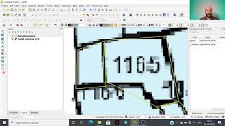
Digitization of Polygon, Line and Point Feature in Topographical Map Using QGIS

4:35:32
Introduction to QGIS (Full Course, Ad-Free)

30:20
How to Make a Map using QGIS3

18:57
How to do Digitization with QGIS 2020 II ডিজিটাইজেশন in QGIS

16:05
How to digitize point, line and polygon features from toposheet in QGIS.
1:37:53
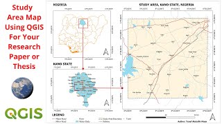
Create Study Area Map For Your Geophysical Research Paper or Thesis Using QGIS

40:45
QGIS pour débutant - Carte complète (téléchargement, traitement + mise en page)

5:41
Georeference Scanned Topographic Map Using QGIS - Made Simple & Easier
11:03