Prepare Elevation Map with Contour Lines in QGIS | Latest Tutorial
12:47
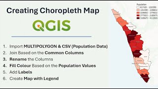
How to Prepare a Choropleth Map Using Population Data | QGIS Tutorial

14:44
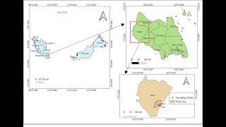
Prepare Study Area Map Easily |QGIS

14:21
QGIS Contours and Contour Labels

1:08:48
Complete QGIS Watershed Delineation Tutorial

5:58
Introducing: the AI Georeferencer for QGIS

14:21
Creating and Styling Contour Lines in QGIS
1:53:40
Create study area map using QGIS: Detailed step by step methods

24:00