How to Create LULC using ArcGIS/ Supervised Classification and Calculate Area of LULC

26:43
How to calculate land surface temperature from Landsat 8 Satellite Data

29:53
LULC change detection using ArcGIS | 2001 & 2021

18:17
Unsupervised Classification | LULC Mapping in ArcGIS
18:18
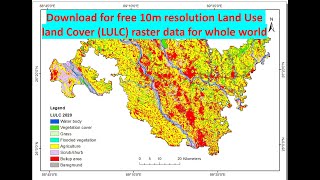
Free download Latest Landuse and Landcover (LULC) raster data for whole world from Esri landcover

32:20
GEE 12: Land Use and Land Cover (LULC) Map, Validation, and Area Calculation of LULC in GEE

27:53
Landsat 8 Image Classification with ArcGIS (Supervised)
30:29
Des Ouvriers du Bâtiment Ingénieux Qui Sont À un Autre Niveau

19:04