Landuse & Landcover Mapping using ArcGIS | Supervised Classification

18:17
Unsupervised Classification | LULC Mapping in ArcGIS

29:53
LULC change detection using ArcGIS | 2001 & 2021

25:21
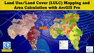
How to Create LULC using ArcGIS/ Supervised Classification and Calculate Area of LULC

32:01
Landsat 8 Image Classification using QGIS
23:56
Containerize your agents!

27:53
Landsat 8 Image Classification with ArcGIS (Supervised)
30:53
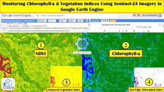
Monitoring Chlorophyll-a & Vegetation Indices using Sentinel-2A imagery in Google Earth Engine
41:22