Reprojetar raster (MDE) no QGIS
8:20
Corrigir MDE com o SAGA GIS no QGIS
20:05
Simbologia de mapa hipsométrico ou de altitude no QGIS

10:58
COMO REPROJETAR COORDENADAS NO QGIS [SHAPE / RASTER]

5:40
Mosaico de Raster no QGIS
12:10
Reprojeção de vetor / shapefile no QGIS - SAD69, SIRGAS2000 e UTM
10:25
Gerar declividade e reclassificar a camada no QGIS
4:44
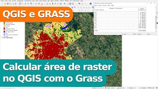
Calcular área de raster no QGIS com GRASS

1:12:46