Flood Simulation and Modeling in ArcGIS
21:26
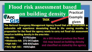
Flood risk assessment based on building density in ArcGIS

17:25
Create Advance Flood Simulation in ArcGIS Pro 3.3
21:29
Flood Animation Mapping

16:47
Quick Flood Analysis with QGIS

18:53
Create and Export Flood Simulation for Adyar River Basin Using ArcGIS Pro 3.3

1:11:02
NAZLI ÖKSÜZ - Akustik Türküler (8)
15:16
Flood Animation using 3D Analyst tools of ArcGIS (ArcScene + ArcMap)

11:05