Vitis maps description
28:22
Spatial Data Analysis
29:05
Species Distribution Modelling using ArcGIS and Maxent Software- Step by Step Guide
39:38
Geospatial Centroid Seminar- State Geographies - CO and OK
23:16
Spatial Intro
28:47
2025 NWS External Partners Greater Mississippi River Basin: Spring Hydrologic Outlook Webinar #1
30:03
How to perform species distribution modeling using the software Maxent
20:25
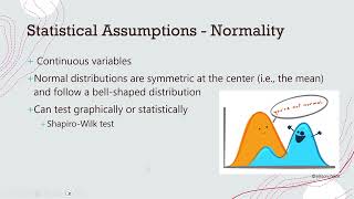
Fundamental Stats Overview

20:44