Third party waypoints! - Use google earth to create and manage waypoints for your Garmin echomap

15:31
Garmin's QuickDraw Contours Explained! - Create your own maps of ANY body of water!

28:34
FIND WAYPOINTS AT HOME!!!! Using Google Earth Pro
12:58
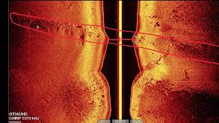
Screen Shot Break Down Pt. 1 - Side Imaging - What am I looking at?!?

16:58
Change Your Fishing Forever With This Google Earth Trick

31:21
Chart Plotter Comparison Argo vs Raymarine Lighthouse on the Tennessee River

15:17
Screen Shot Break Down Pt.2 What are we looking at!?! - Down Imaging/2D
22:23
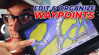
How to Organize and Edit Your Garmin Echomap Waypoints with Homeport on your PC!

16:45