LiDAR Data Processing with DJI Terra and Advanced Post-processing with TerraSolid Walkthrough

22:01
Como SUPERCARREGAR seus dados LiDAR DJI L1/L2 | Drone LP360

54:43
How to Use DJI Terra for Photogrammetry

42:15
Processing LiDAR data in QGIS 3.32 - The latest QGIS improvements to point cloud capabilities

15:17
Photogrammetry VS LiDAR - Which Is BETTER?
12:54
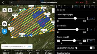
DJI/M300/L1 DJI Pilot 2 Lidar Mission Planning With Terrain Following

1:05:22
Master LiDAR Data Processing (Full Walkthrough!)

12:52
DJI Terra PPK L1

24:30