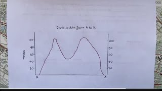
How to Draw River Cross Sectional Profile in Google Earth Pro ||

5:53
UTM Zone || How to Find UTM zone in Google Earth ||

7:35
Google Earth - Longitudinal/Cross Section Elevation Plan & Profile Distance Measure | Success 555

7:59
How to Draw Elevation Profile in Excel from Google Earth Pro Data || River Profile in Excel ||
14:02
Geography mapwork: Cross section/mapping and intervisibility
12:48
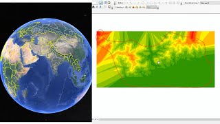
DEM Generation From Google earth

30:25
Garmin eTrex 30x GPS || All Details || Working Process Etc ||

8:40
Downloading High-Resolution Topographic Maps for Free

26:49