Detectar automáticamente el cambio del uso del suelo usando QGIS

1:57:42
Monitoreo de Bosques mediante imágenes satelitales en el software QGIS
22:07
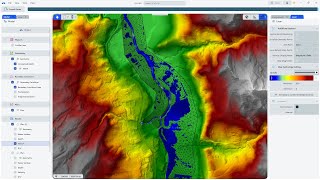
Simular una inundación con el nuevo RAS Mapper 2025
19:52
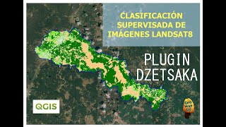
Clasificación de la cobertura del suelo en QGIS | Plugin DZETSAKA

35:53
Análisis del cambio de cuerpos de agua en Google Earth Engine con Surface Water Tracker

30:39
DeepSeek vs ChatGPT vs Claude creando código para Google Earth Engine

13:36
Lawrence: Trump humiliated on the world stage as France's Macron instantly corrects his Ukraine lie

1:07:03
【R&B Relax 4】Cozy Playlist / for Chill / Work / Indie / Ballad / Relax / Coffee

3:25:28