Wildlife Analysis in ArcGIS Pro, #2 of 2: Kernel Densities
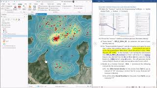
33:37
Wildlife Analysis in ArcGIS Pro: Using Kernel Densities to estimate Home Ranges and Core Areas

20:19
Raster and Surface Analysis in ArcGIS Pro, Episode 1: Common Raster Analytical Methods

30:38
Estimating Space-Use with Kernel Density Estimation | Lecture

51:36
Cartography 2025 @ IU Indy - Exercise 1 Demonstration

17:44
Kernel Density in ArcGIS Pro

12:09
Raster Lab 5: Calculating TPI, or the Topographic Position Index, in ArcGIS Pro

18:01
Home Range Analysis Part 3

8:54