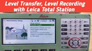
how to use Transfer height laica ts10 | Level work with total station

4:31
Leica ts 10 total station Stakeout method|| Layout by Leica ts 10 total station|| part 2

20:19
how to start topo with Dxf file
5:31
How to use Leica TS10 total station as an Auto Level Mechine?

8:22
Total Station Setup: Using Station & Backsight Coordinates with Leica TS02

12:59
Laser Land Leveller

17:06
pipe line levelling & Alignment part2

35:48
How to Calculate Height of Collimation (HOC) & Rise and Fall Methods for Site Engineering Surveying

12:42