How to create Ground water level map or Depth to water level map using ArcGIS Pro
14:26
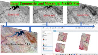
How to create Band Composite and Mosaic using Landsat 8 Data in ArcGIS Pro

25:36
How to Delineate Watershed using DEM data in ArcGIS Pro

9:15
Cline 3.3 (actualizado) + API O3 Mini gratuita: ¡Esta NUEVA ACTUALIZACIÓN hace que este codificad...

13:28
How to prepare Spatial Distribution map of Laboratory Results of samples of water, soil, etc.

1:06:31
Delineation of Groundwater Potential Zones Using GIS/Remote sensing Techniques and AHP

6:26
Make groundwater level map

36:25
ArcGIS Pro: Lab 03: Georeferencing

21:46