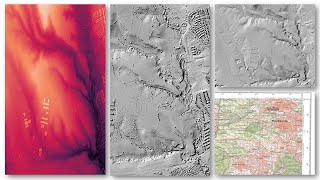
🛰️ 💻¿Qué permite analizar la visualización de datos LiDAR con QGIS?

8:34
COMO HACER TU PLANO TOPOGRÁFICO RAPIDAMENTE CON QGIS | CURVAS DE NIVEL FÁCIL ✅RECURSOS GRATIS !!!🟢
14:15
Datos LIDAR QGIS: Visualización y procesado de datos - ✌ Rápido y sencillo

40:17
Laboratório Virtual de Meteorologia Sinótica (L.V.M.S.) - 07/02/25

56:09
Manejo profesional de LIDAR en 2021

13:16
Let's scan the whole planet with LiDAR | Chris Fisher

4:35:32
Introduction to QGIS (Full Course, Ad-Free)

9:38
How to extract contour lines from Google Earth To Autocad

24:40