How to prepare a Temperature map for whole world in ArcGIS? II Maximum Temperature II Map layout

3:35
How to change cell size of raster dataset in ArcGIS II Change spatial resolution I Change pixel size

17:50
Long term average annual rainfall: NetCDF file to raster for whole world in ArcGIS

15:51
How to calculate Land Surface Temperature from Landsat 9 using ArcGIS II Heatmap II Dr. Jayanta Das

14:57
Download DEM/Elevation, Slope, Roughness, Aspect Map in just One Click

7:07
DeepSeek, TikTok, Temu: How China is taking the lead in tech - BBC World Service

20:55
How Medieval Peasants Survived Freezing Winters
21:38
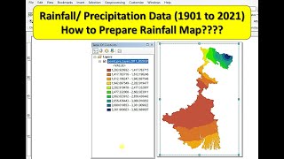
Rainfall Map in ArcGIS || Annual Average Rainfall Map in ArcGIS ||How to Download Precipitation Data

16:31