Géographie Cartographie : Exemples de questions d'examen sur le relèvement vrai et le relèvement ...

11:18
Cartographie géographique : Comment calculer le gradient (pente) sur une carte Partie 2

8:42
Geography Mapwork: True bearing and Magnetic bearing.
26:19
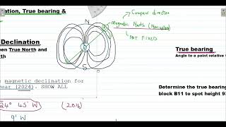
MAPWORK CALCULATIONS| DETERMINING MAGNETIC DECLINATION, TRUE BEARING & MAGNETIC BEARING |MADE SIMPLE
1:28:23
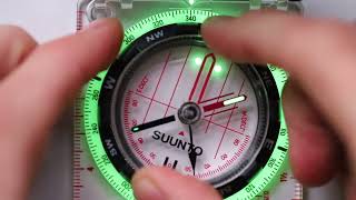
How to use a map and compass IN DETAIL

21:40
MASTERING TOPOSHEET SKILLS - CLASS 10 - ICSE - 2025 - CONVENTIONAL SYMBOLS

5:54
Mapwork magnetic declination and bearing calculations

13:20
Comment fonctionne l'alimentation triphasée : pourquoi 3 phases ?

12:53